
Drone Mapping, LiDAR and Digital Twin Systems (2026)
(Global Analysis – Data, Infrastructure & Intelligence)
— Analysis by Gürkan Bal
Founder & Editor | UAV Intelligence
🗺️ Mapping Revolution: From Land to Data
Mapping is no longer about maps.
With drone technology, mapping has evolved into a data production and intelligence system.
Traditional mapping:
👉 slow + expensive + limited
Drone-based mapping:
👉 fast + precise + scalable
Drones enable:
- centimeter-level accuracy
- real-time data collection
- 3D modeling of entire environments
👉 Drones are no longer mapping tools;
they are data infrastructure systems.
📡 Core Technologies: Photogrammetry vs LiDAR

📷 Photogrammetry
Photogrammetry uses images to create maps and 3D models.
Applications:
- orthophoto maps
- terrain modeling
- construction monitoring
Advantages:
- cost-effective
- high-resolution visuals
🔦 LiDAR (Light Detection and Ranging)
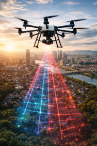
LiDAR uses laser pulses to measure distance and create precise 3D data.
Applications:
- forest structure analysis
- terrain mapping under vegetation
- infrastructure inspection
Advantages:
- penetrates vegetation
- extremely high accuracy
- reliable elevation data
👉 Photogrammetry = visual accuracy
👉 LiDAR = structural accuracy
👉 Together = complete digital representation
🏗️ Digital Twin Systems
Drone data enables the creation of Digital Twins:
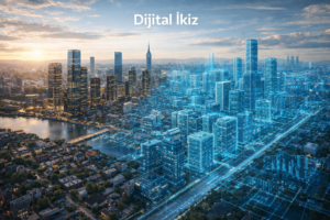
👉 real-time virtual replicas of physical environments
Used in:
- smart cities
- infrastructure monitoring
- construction projects
- industrial facilities
Benefits:
- real-time tracking
- predictive maintenance
- risk reduction
👉 Digital Twin = future of infrastructure management
🏗️ Construction and Engineering Applications
Drones are transforming construction workflows.

Use cases:
- site surveying
- progress tracking
- volume calculation (cut/fill)
- project monitoring
Benefits:
- reduced survey time (days → hours)
- improved accuracy
- transparent reporting
👉 Drone = construction control center
⚡ Energy and Infrastructure Mapping
Drone mapping is critical for:
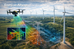
- power line inspection
- pipeline monitoring
- solar farm analysis
- wind turbine inspection
LiDAR enables:
- precise structural analysis
- fault detection
- risk prevention
👉 Drone mapping = predictive maintenance system
🌍 Urban Planning and Smart Cities
Drone data is used for:

- city modeling
- traffic analysis
- zoning and planning
- infrastructure expansion
👉 Cities are becoming data-driven ecosystems
🌲 Environmental Monitoring
Drone mapping supports:
- deforestation tracking
- biodiversity analysis
- erosion monitoring
- water resource management
👉 Drone = environmental intelligence system
💻 Data Processing and Software Ecosystem
Drone mapping is not just about flying.
The real value is in data processing:
- 3D modeling software
- cloud-based mapping platforms
- AI-powered analysis
👉 Drone → Data → Processing → Insight
👉 This is the core of UAV Intelligence
💰 Business Models and Revenue Streams
1. Mapping Services
- land surveying
- construction mapping
- infrastructure analysis
2. Data-as-a-Service
- 3D models
- GIS data
- analytics reports
3. Digital Twin Solutions
- real-time monitoring
- subscription-based systems
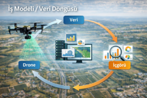
👉 The real value is not in flying—
it is in processing and selling data
⚠️ Regulations and Operational Limits
Drone mapping operations require:
- flight permissions
- licensing
- data compliance
Regulated by:
🧠 Future: Autonomous Mapping and AI
Future trends:
- autonomous mapping missions
- AI-based object detection
- real-time digital twin updates
👉 Mapping will become:
✔ automated
✔ continuous
✔ intelligent
🎯 Conclusion
Drone mapping and LiDAR systems:
- transform physical environments into data
- enable real-time decision-making
- reduce costs and risks
- create new digital economies
👉 Mapping is no longer geography—
it is data intelligence
🔗 Continue
👉 Drone Mapping & LiDAR Market, ROI and Deep Analysis (2026) →
👉 LiDAR vs Photogrammetry: Which One Should You Choose? →
👉 How to Start a Drone Mapping Business (2026 Guide) →
👉 Best Mapping Software and Tools (Pix4D, Metashape, DJI Terra) →
👉 Drone Mapping Equipment Guide (RTK, LiDAR, Sensors) →
— Analysis by Gürkan Bal
Founder & Editor | UAV Intelligence