

Drone Economy: Global Use Cases, Sectoral Transformation, and Future Roadmap (2026 – Current)
Global Industry Analysis)
— Analysis by Gurkan Bal
Founder & Editor | UAV Intelligence
Unmanned aerial vehicles (UAVs) and drone technologies have evolved beyond military and hobby use over the past decade, transforming into a multi-sectoral economic system on a global scale.
As of 2026, drones are no longer just data collection tools;
they are systems that manage operations, perform analysis, and provide decision support.
his transformation has moved aviation beyond being a one-dimensional transportation activity, creating a new economy based on data, services, and autonomy — a shift increasingly recognized by global aviation authorities such as the FAA and EASA .
🌍 Global Structure of the Drone Economy
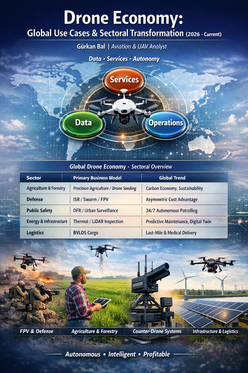
Today, the drone ecosystem is growing along three main axes:
- Services: filming, spraying, inspection, field operations
- Data: mapping, analysis, artificial intelligence, object detection, decision support
- Operations: logistics, security, autonomous systems, continuous surveillance, BVLOS missions
This structure unifies use cases that may appear independent across different sectors into a single economic and technological system.
📊 Global Drone Economy – Sectoral Overview
| Sector | Primary Business Model | Global Trend |
| Agriculture & Forestry | Precision agriculture / Drone Seeding | Carbon economy, sustainability |
| Defense | ISR / Swarm / FPV | Asymmetric cost advantage |
| Public Safety | DFR / Urban surveillance | 24/7 autonomous patrolling |
| Energy & Infrastructure | Thermal / LiDAR inspection | Predictive maintenance, digital twin |
| Logistics | BVLOS cargo | Last-mile and medical delivery |
📊 For comprehensive market sizing and sectoral growth forecasts, industry reports such as PwC’s Global Drone Market Study provide detailed economic analysis.
🚀 Global Drone Use Cases (Complete Sectoral Map)
🎬 1. Media, Advertising, Tourism, and Digital Show Economy
Drone technology has fundamentally transformed visual production and brand communication. Film, TV series, commercials, and documentary productions; corporate promotional videos; tourism and destination marketing; live event coverage; sports, automotive, and action content are now being reimagined through drone-based visual language.
This field is not limited to classic aerial shots. FPV cinematic tracking shots, single-shot dynamic scenes, low-cost high-impact productions, and the rapidly growing drone light show applications are part of this category. As of 2026, the drone light show market has begun replacing the fireworks industry, creating an environmentally friendly, repeatable, and brand-integrated show economy.
👉 Here, the drone is not just a camera; it is a tool of visual narrative, brand power, and the attention economy.
Continue: Drone advertising and production economy →
🌾 2. Agriculture, Livestock, and Forestry (Agro-Ecosystem)
Drones are transforming agriculture from an intuition-based activity into a data-driven production model. Precision spraying, fertilization, NDVI and multispectral analysis, water stress detection, yield mapping, and early disease detection are at the center of this transformation.
In livestock, herd tracking, pasture monitoring, surveillance of large rural areas, locating lost animals, and monitoring movement patterns stand out. This provides significant time and labor savings, especially on large lands.
In forestry, drones are used not only for fire surveillance but also for carbon emission analysis after fires, drone seeding for reforestation in inaccessible areas, and forest carbon stock monitoring for carbon stock tracking. This creates a new revenue and project area linked to environmental funds and carbon credit mechanisms.
👉 Here, the drone becomes a multi-layered field system bridging production, environment, and sustainability.
Continue: Starting a business with agricultural drones and revenue models →
🗺️ 3. Mapping, Geodesy, LiDAR, and Digital Twin
One of the highest value-added areas of the drone economy is data production. Photogrammetry, LiDAR scanning, orthophoto production, topographic modeling, cadastral support, volume calculation, and digital twin generation form the backbone of this category.
This field provides critical data for urban planning, public infrastructure, private engineering, mining, energy, and construction sectors. Here, the drone is not just an image-capturing device but is positioned as a measurement, modeling, and decision infrastructure.
👉 The real value lies not in the flight itself but in the economic value of the precise data generated.
Continue: Starting a professional business with mapping drones →
🏗️ 4. Construction and Site Management
Drone use in construction includes daily progress tracking, site inspection, BIM integration, volume and quantity calculation, excavation measurement, occupational safety monitoring, and project reporting.
With regular aerial data on large-scale projects, project managers can track progress without being physically present on site, managing the time-cost-risk triangle more effectively. Therefore, the drone now functions on construction sites not just as an “eye” but as a digital control and optimization system.
👉 Drone use in construction not only accelerates inspection but also raises the data quality of project management.
Continue: Service models with construction drones →
⚡ 5. Energy and Critical Infrastructure Inspection
Power transmission lines, solar power plants, wind turbines, pipelines, transformers, dams, and critical infrastructure are now inspected more safely and economically with drone systems.
Thermal analysis, corona discharge detection, panel and cell-level fault detection, turbine blade inspections, pipeline leak detection, and structural observation at high-risk points are the core applications of this field.
Here, drones shift maintenance processes from the classic “react after failure” model to a predictive maintenance model. This reduces costly failures and downtime.
👉 In the energy sector, drone = early warning and risk reduction system.
Continue: Drone use and revenue models in the energy sector →
🏭 6. Industrial and Manufacturing Inspection
Factories, refineries, storage areas, production facilities, tanks, chimneys, silos, and hard-to-reach industrial zones can be inspected more safely with drones.
The main advantage of this use is collecting data without sending personnel into hazardous areas. Drone use in environments with high heat, confined spaces, high-altitude work, or chemical risks increases both occupational safety and operational efficiency.
👉 Here, the drone is not just an inspection tool but an industrial instrument that ensures production continuity.
Continue: Drone use in industrial inspection →
🧼 7. Industrial Services and Surface Applications
One of the newer but rapidly growing areas of the drone economy is exterior cleaning, high-rise building washing, painting/coating, and hazardous surface applications.
Drone systems, which offer cost, speed, and safety advantages over traditional crane-scaffolding models for skyscrapers, hospitals, factories, and hard-to-reach surfaces, are generating next-generation business opportunities, especially for entrepreneurs and service models.
👉 Here, the drone is not just technology but a business model and field service tool.
Continue: Starting a service business with drones →
⛏️ 8. Mining and Quarry Management
In mining sites, drones are used for stockpile volume measurement, site planning, bench design, excavation area analysis, safety monitoring, and logistics optimization.
With rapid data production over large areas, drones provide both measurement convenience and decision support for mining operations. Drone-based stockpile measurement achieves up to 90% time savings compared to traditional ground-based methods. This makes sites more controlled, more visible, and more efficient.
👉 In mining, drone = data-driven site management.
Continue: Drone services in mining →
🚓 9. Public Safety and Traffic Operations
Drone systems are becoming increasingly critical in urban security, incident management, and emergency response. The Drone as First Responder (DFR) model, in particular, reaches incident scenes before ground personnel, providing real-time imagery and situational awareness.
Traffic flow monitoring, crash scene investigation, 3D accident reconstruction, crowd analysis, event security, and field management during crises are the primary applications of this category.
Here, the drone is not just a surveillance device but becomes a real-time urban management and security decision support system.
👉 In public safety, drones shorten response times and increase information quality.
Continue: Public safety and traffic drone operations →
🧪 10. Narcotics, Border, and Security Operations
Equipped with night vision, IR, thermal, and hyperspectral systems, drones are used to detect illegal cultivation sites, monitor borders, track smuggling routes, and scan suspicious activities from the air.
What distinguishes this field from public safety is that the drone is used here more directly for intelligence generation. Drones provide critical advantages in rural, border, and hard-to-reach areas where ground teams are limited.
👉 Here, the drone does not just produce imagery; it generates intelligence, traces, and patterns.
Continue: Drone use in narcotics and border security →
🪖 11. Defense and Military Systems
One of the origins of drone technology is the defense sector, and this category remains one of the fastest-evolving areas today. ISR missions, tactical reconnaissance, micro drone systems, FPV-based close-range missions, swarm drone technologies, autonomous attack, and support platforms form the main axes of this category.
The importance of drones in modern defense is not only technical but also economic. The asymmetric cost advantage is at the center of this transformation.
Economic warfare doctrine:
The cost of an FPV drone is typically in the hundreds or a few thousand dollars, while the target it neutralizes can be a million-dollar tank, armored system, or missile platform. This ratio clearly demonstrates why modern defense planning is increasingly shifting toward drone-based systems.
Kamikaze/loitering munition systems, tactical FPV platforms, and micro reconnaissance drones have become part of this new warfare doctrine.
👉 In defense, drone = not just a platform, but a doctrinal shift.
Continue: Defense UAV systems →
🆘 12. Disaster Management and Search & Rescue
In earthquakes, floods, fires, landslides, and large-scale crisis zones, drones play the most critical role in the first minutes. Thermal human detection, damage assessment, live data transmission, rapid mapping, and team coordination make a significant difference in disaster management.
These systems, which precede ground teams in hazardous and hard-to-reach areas, reduce time loss and guide search-and-rescue operations.
👉 In disaster zones, drone = the first to see, first to map, first to direct.
Continue: Drone operations in disaster management →
🚑 13. Healthcare, Medical Logistics, and Emergency Delivery
Drones generate value in healthcare, especially in time-critical scenarios. Transporting blood, biological samples, medicine, vaccines, AEDs, and other emergency equipment are the core applications of this field.
Drone use in remote areas, disaster zones, and congested cities prone to traffic delays reduces the geographical limitations of healthcare services.
👉 In healthcare, drone = delivering time to places you cannot reach.
Continue: Drone use in the healthcare sector →
🚚 14. Logistics, Cargo, and Last-Mile Delivery
Drone logistics is growing around last-mile delivery, rural access, critical part transportation, emergency material transport, and BVLOS-supported distribution networks.
Rather than completely replacing conventional ground transportation, this system creates a new layer that complements it, especially in time-sensitive and hard-to-reach scenarios.
👉 Drone logistics = the speed layer of transportation.
Continue: Drone cargo systems →
🎮 15. FPV Drone: Next-Generation Operations
FPV systems are not just for racing or hobbies. Confined space inspection, indoor observation, closed-volume inspection, micro reconnaissance missions, cinematic chase shots, and tactical close-range use form the foundation of this category.
The power of FPV lies in the level of control that gives operators a “being there” sensation and the maneuverability it offers. Therefore, it has become a distinct category in media, inspection, and tactical applications.
👉 FPV = the solution for inaccessible areas.
Continue: What is an FPV drone and where is it used? →
🔌 16. Tethered Drone Systems
Tethered drone systems overcome battery limitations, enabling prolonged and uninterrupted flight. These systems are particularly valuable for stationary surveillance, event security, military bases, critical facilities, and border zones.
Uninterrupted power and continuous live data streaming make tethered drones a separate operational class.
👉 Tethered drone = the eye that stays in the air continuously.
Continue: Tethered drone systems and use cases →
🚓 17. Autonomous Patrol Drones
Autonomous patrol drones are increasingly used in smart cities, campuses, industrial facilities, and high-security areas. These systems can fly automatically on predetermined routes, detect anomalies, and send alerts to operators.
This field demonstrates the shift from human-centric security models to system-centric ones.
👉 Autonomous patrol = continuous security, low human dependency.
Continue: Autonomous patrol drone systems →
🛑 18. Anti-Drone Systems (Counter-UAS)
The growth of the drone economy is also expanding counter-drone defense systems. RF detection, radar-supported tracking, jammer systems, GPS spoofing, and drone capture technologies form the core of this category.
Airports, military installations, public buildings, large event venues, and critical infrastructure now require anti-drone solutions as a distinct market.
👉 The defense layer of the drone economy = the Counter-UAS ecosystem.
Continue: Anti-drone systems and airspace security →
🌦️ 19. Meteorology and Atmospheric Analysis
Drones are increasingly used for microclimate measurements, air quality monitoring, greenhouse gas analysis, smoke and storm observation, and other atmospheric missions.
This field creates a new research and application layer for environmental data collection, pre-disaster analysis, and climate-based projects.
👉 Meteorological drones = close-range data collectors of the atmosphere.
Continue: Meteorology and atmospheric drone systems →
📊 20. Insurance, Appraisal, and Risk Analysis
Drones provide fast, visually evidence-based solutions for damage assessment, roof and building inspections, post-disaster appraisal, policy verification, and risk modeling.
Producing data on-site without delay after natural disasters, in particular, offers cost advantages in insurance and appraisal processes.
👉 In insurance, drone = on-site evidence generation system.
Continue: Damage assessment with drones in insurance →
🌍 21. Environment, Climate, and Ecosystem Monitoring
Carbon tracking, air quality, habitat analysis, wildlife observation, coastal change, forest health, and environmental pressure monitoring are environmental use cases for drones.
This category demonstrates that drones are becoming critical tools not only for commercial purposes but also for sustainability and ecological management.
👉 In environment, drone = a measurement system that makes the invisible visible.
Continue: Drone use in environmental and climate monitoring →
🌊 22. Maritime, Coastal, and Port Operations
Port inspection, coastal surveillance, maritime search and rescue, shipboard inspection, and coastal infrastructure observation are the core applications of this category.
In maritime operations where water access is difficult or risky, drones provide significant speed and safety advantages.
👉 In maritime, drone = access, observation, and safety advantage.
Continue: Drone systems in maritime and port operations →
🛰️ 23. Telecommunications and Communication Infrastructure
Base stations, communication towers, antenna systems, and hard-to-reach high structures can be inspected faster and more safely with drones.
This field reduces risk for maintenance teams while shortening operational time.
👉 In telecom, drone = the fast way to inspect high-risk assets.
Continue: UAV advantages in telecom tower inspections →
🏡 24. Real Estate and Property Visualization
Luxury residences, commercial projects, land parcels, and large-scale real estate investments can be marketed more effectively with drone imaging.
Aerial views, contextual surroundings, lifestyle presentation, and visualization of project scale are the core marketing strengths of this field.
👉 In real estate, drone = a sales tool that makes spatial value visible.
Continue: Value enhancement methods with drones in real estate →
🎓 25. Education, Certification, and Pilot Ecosystem
The growth of the drone economy is also expanding the education and human resources ecosystem. Pilot licensing, certification, simulation training, corporate procedures, and professional operator development are the foundation of this field.
Today, the industry is sustained not only by hardware sales but also by instructors, flight schools, software training, and operational procedures. Certification authorities (SHGM, EASA, FAA) and authorized training institutions form the regulatory and developmental pillars of this ecosystem.
👉 Education = the human capital infrastructure of the drone economy.
Continue: Roadmap to becoming a professional UAV pilot →
🧠 26. R&D, Autonomy, and Future Systems
Autonomous flight, AI-powered decision systems, swarm technologies, extreme environment testing, indoor autonomy, and next-generation aerial platforms are shaping the future of the drone economy.
Here, the focus is not only on today’s operations but on building tomorrow’s aerial systems.
👉 R&D = the long-term direction-setting center of the drone economy.
Continue: Autonomy, AI, and future drone systems →
💻 The True Center of the Drone Economy: Data
A drone is not just a flying device.
The real value lies in:
- collected data,
- processed data,
- analyzed data,
- and the commercialization of this data.
🧠 UAV Intelligence
The most critical evolution of drone technology is not just flight but the strengthening of the UAV Intelligence concept.
Now, drones:
- collect data,
- find patterns,
- detect objects,
- identify anomalies,
- generate decision support.
👉 The real value is not in the flight but in the post-flight interpretation.
📊 New Economic Model
Therefore, the modern drone economy is moving toward two main models:
- Drone-as-a-Service (DaaS)
- Data-as-a-Service
In other words, the real profit is often not in the device itself but in the service and data it generates.
🌐 Future: Autonomous and Connected Systems
The future of the drone economy will be shaped by:
BVLOS operations, UTM systems, AI-powered flight, smart city integrations, and interconnected drone networks.
In the near future, drones will cease to be independent vehicles and become structures that work within networks, communicate with each other, and share data with central systems.
👉 The drone model of the future = not a single device, but a connected system.
🎯 Conclusion: Not a Single Sector, But a New Global System
Drone technology is no longer just a device.
It is no longer just a sector.
Today, drones have become a global system that operates across a vast range of fields—from security to agriculture, healthcare to logistics, media to environmental management—producing data, providing decision support, and creating economic value.
Within this system:
- operators,
- data analysts,
- engineers,
- software developers,
- field specialists,
- security professionals,
- educational institutions,
- and service providers
all coexist.
In other words, the drone economy is not just about devices flying in the sky;
it is the name of a new digital-industrial order.
🔗 What’s Next (Series Start)
Following this main guide:
- detailed analysis of each sector,
- business models,
- revenue potential,
- equipment selection,
- regulatory aspects,
- and real-world field applications
will be covered in separate sections.
Gürkan Bal | Aviation & UAV Analyst